Save this image free of charge
in 800 pixels for layout use
(right click, Save as...)
|
|
Ref : V01742
Theme :
Earth in Space (419 images)
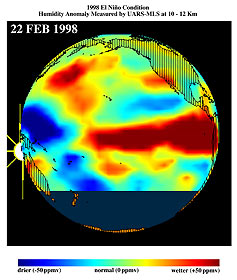
Title : TOPEX/El Nino Watch - El Nino Moisture in the Atmosphere, February 22, 1998
Caption :
This image shows differences in atmospheric water vapor relative to a normal (average) year in the Earth's upper troposphere about 10 kilometers (6 miles) above the surface. These measurements were made by the Microwave Limb Sounder (MLS) instrument aboard NASA's Upper Atmosphere Research Satellite (UARS). This image, obtained on February 22, 1998, shows that high levels of atmospheric water vapor (red) continue to persist above the warm water pool, commonly referred to as El Nino, in the eastern equatorial Pacific Ocean. This image also shows high levels of atmospheric moisture above Southern California. The extent of this high moisture area along the equator has slightly decreased since late January, which corresponds to the shrinking volume of the warm water pool on the ocean's surface. During El Nino, the warmer ocean water off the coast of Peru evaporates at a higher rate, and the resulting warm moist air rises, forming tall cloud towers. In the tropics, the warm water and the resulting tall cloud towers typically produce large amounts of rain. These data show a new formation of high levels of moisture off the coast of Japan in an area that is the typical breeding ground for winter storms. Storms produced off the coast of Japan normally migrate eastward toward the western United States. During this El Nino condition, the southern tropical jet stream has shifted northward, bringing additional moisture from the tropics. When these two sources of moisture converge near California, they produce storms with higher-than-normal rainfall.
|
|

